
TIWAG is planning to expand the existing Kaunertal storage power plant. These plans are not new, but still red-hot. In the coming weeks we will explain exactly what these expansion plans look like, what negative consequences are to be expected and why WET will campaign against this expansion. Below you will find an overview of the existing Kaunertal power plant and what the expansion plans include.
The existing power plant
The Kaunertal storage power plant was built in the 1960s and is fed from a large reservoir (Gepatschspeicher). 11 streams from 3 different catchment areas are fed into the reservoir lake or directly into the pressure shaft. In order to produce electricity, the water is discharged via an approx. 13km long pressure tunnel to the powerhouse in Prutz (736m difference in altitude, 122m³/s expansion water volume). The water is then discharged into the Inn River. Depending on the reservoir level, the power plant has an output of 325 – 392 MW and a regular annual generation of 661 GWh. More technical data on the power plant can be found in the TIWAG brochure on the Kaunertal power plant and on the TIWAG website.
The planned expansion
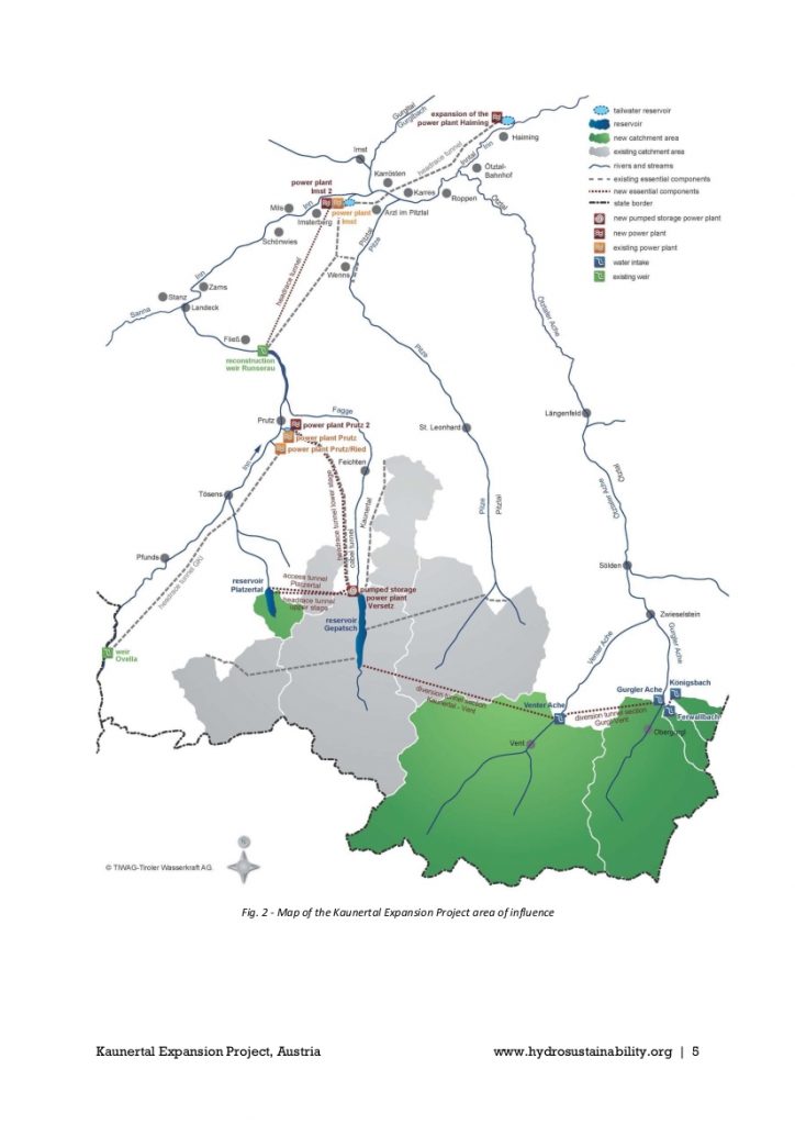
‚Expansion‘ sounds innocent enough at first – the power plant is already in place, the damage is done, what’s wrong with expanding it to use the existing resources more efficiently? Upon closer inspection it quickly becomes clear that behind this expansion is a mega-project that stretches from the Ötz valley over the Platzertal and Kaunertal valleys all the way down to the town Imst on the Inn River – where it then meshes with another project that affects the Inn down to Haiming. Viewed as briefly as possible, all this means the following:
- 2 Tyrolean weirs as water catchments on the Königsbach and Ferwallbach ((5) p. 8)
- 2 concrete dams of 25m each as water catchments on the Gurgler and Venter Ache ((5) p. 8)
- Degradation of the Venter Ache, the Gurgler Ache and the Ötztaler Ache to residual water channels and the associated massive interference in the water balance of the entire Ötz Valley ((7) p. 4) – a total of ~90 river kilometers will become residual water channels
- 1 new reservoir lake in the Platzertal with a capacity of about 42 million cubic metres and a dam of 119m height ((3) p. 1)
- Destruction of the Platzertal high valley, and in particular of 6,3 hectares of moorland
- 3 new power plants (Versetz, Prutz 2 and Imst 2) ((5) p. 4)
- 4 new tunnels with a total length of approx. 47km ((5) p. 8)
- Destruction of the ecological functioning of the Inn River over a length of about 4.2 kilometres ((7) p. 4)
- numerous construction sites and auxiliary construction facilities during the years-long construction phase and various accompanying measures such as huge hydropeaking basins or material dumps with a total area of 16.8 hectares ((3) p. 2 & (7) p. 1)
In a nutshell – this goes beyond any kind of nutshell. Take a look at the graphic to get an overview of how huge the expansion plans are!
Our main concerns
The expansion plans are so enormous that we cannot outline everything here. Therefore, here are the points that seem most important to us at the moment:
Diversion of the Venter and Gurgler Ache rivers
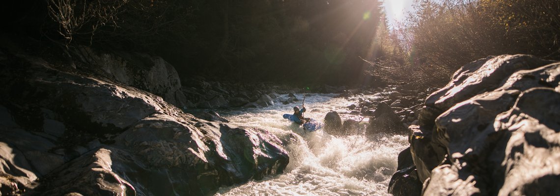
The Venter and Gurgler Ache will be diverted, for this purpose a tunnel with a total length of approx. 23km will be built from the Gurgler and Venter Ache to the Gepatsch reservoir, which can transfer a water volume of 82m³/s ((3), p.1). It takes 80% of the water from the Venter and Gurgler rivers, up to 29m³/s from the Gurgler and 50m³/s from the Venter Ache ((4), section 1.4.2.1), and also 85% of the water from the Königsbach and Verwallbach ((5), p. 152). Except in the months of December to April, when the base is 2m³/s. This is to ensure that there is enough water availbale further downstream for ski slope snowmaking ((5), p. 152, 153) You’ve read correctly – welcome to Tyrol, apart from litterally anything else snowmaking has of course been taken into consideration! This means that the Ötztaler Ache will have up to 80m³/s less water. For kayakers, the effects of the expansion of KW Kaunertal are so catastrophic that we will deal with this topic in separate articles. According to the Hydropower Sustainability Assessment Protocol (HASP) ((5), p. 101), even the rafting season on the Lower Ötz will be shortened to only 3 weeks per year. According to the Nature Conservation Plan for Waters Tyrol, the Venter and Gurgler Ache have an important natural significance: they are classified as worthy of preservation or very worthy of preservation. Likewise the Kühtrain Gorge of the Ötztaler Ache shortly after the confluence. So here alone, important habitats would be impaired or destroyed. All three river ecosystems will suffer severely from being degraded to residual water channels. We do not consider it acceptable that an energy company should be allowed to secure water rights in the valley on such a massive scale. All the more so because in the future the water reserves of the Ötztal will fade with the glaciers declining and the abundant summer water levels will be history. Many farmers in the Ötztal are worried that they will not have access to the water they need in the future ((6)).
Flooding of the Platzertal
The Platzertal is a picturesque, pristine alpine high valley and habitat for many protected animal and plant species. So far, however, TIWAG does not seem to have taken much trouble to document which habitats of which species it would destroy here, and they also seem confused about how much of it actually is: for example, according to TIWAG, the size of the affected mooreland has almost halved as if by magic (look here: (7), p. 4 and (3), pp. 7-8). In any case, the new reservoir would cause the loss of about 6,3ha (9 football fields) of moorland here. According to the Tyrolean Environmental Ombudsman’s Office, the project thus violates the wetlands protection provisions laid down in the Soil Protection Protocol of the Alpine Convention ((7), p.3f ).
Surge and Sink on the Inn
Since the Inn between Runserau and Imst (or Haiming) is to be diverted in the future, it is argued that this would reduce the surge and sinking effects of the power plants on the upper Inn on this stretch. However, the water coming from the Kaunertal power plant will first be diverted into the Inn at Prutz. The surge peaks here will almost double over the approx. 4km between Prutz and the Runserau weir compared to the current situation ((7), p.3). In order for the Inn to serve as such a surge basin, it must be dredged to a depth of about half a metre between Prutz and the Runserau weir and secured by river engineering. In addition, the Runserau weir will be raised ((7), p.3). To compensate, the fish will be offered a lift and a bypass channel, part of which will be an illuminated tunnel ((3), p. 19) – sounds like an April Fool’s joke, but unfortunately it is not.
Sources and links
Eine Antwort
Janine Hofmann
Vielen Dank für eure Unterstützung in dieser wichtigen Sache! Dieses Mega-Projekt muss mit allen Kräften gestoppt werden, weil wir die Natur nun endlich schützen müssen.