
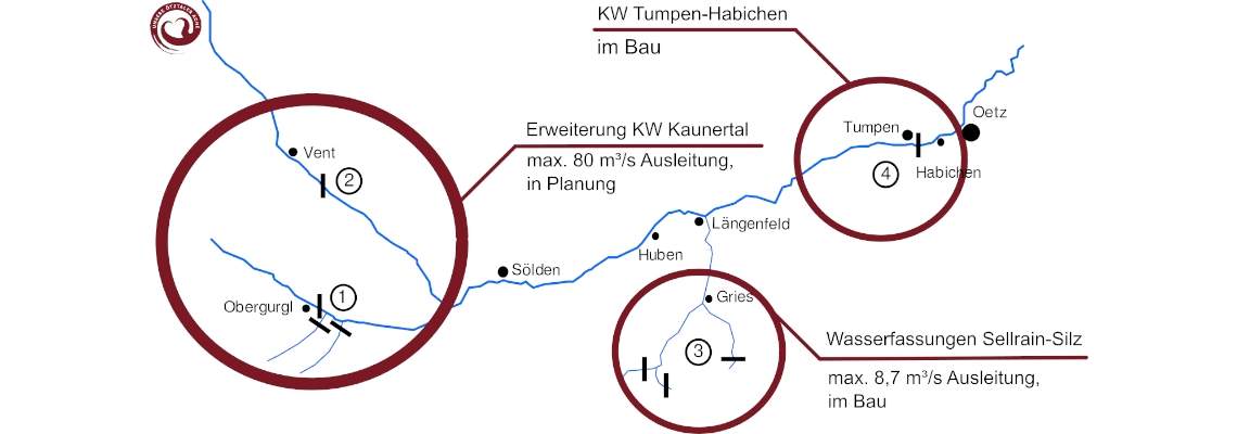
There is no kayaking in Kaunertal, where the heck is Platzertal and why should this concern you as kayakers anyway? It’s simple – all the planned water diversions for the expansion of the Kaunertal power plant come from the catchment area of the Ötztaler Ache. All the water that is supposed to fill this huge new reservoir lake (42 million cubic metres capacity) in Platzertal is missing in the Ötz. (1) The biggest part of the Venter Ache and the entire Ötztaler Ache will become residual water channels – they will be deprived of the majority of their natural runoff – more precisely 80% or up to 80m³/s respectively. In addition to that another almost 9m³/s will be diverted from the Ötz for the Sellrain-Silz power plant. The residual water in the riverbed of the Venter, Gurgler and thus also Ötztaler Ache then will only show a very weak version of the powerful daily and seasonal fluctuations that make the rivers so special. (1) What this means in detail is summarised below.
Venter Ache
It is planned to divert 80% of the water from the Venter Ache – up to 50m³/s. ((2), section 1.4.2.1) The 25 meter high dam for the water catchment would be built directly in the section ‚Obere Venter Ache‘, slightly below the put-in. The ‚Obere Venter Ache‘, the ‚Heiligkreuz‘ gorge and the ‚Untere Venter Ache‘ would thus be diverted. On the one hand, all three sections need the high water levels of summer to be washed free of wood, mudslides and avalanches. On the other hand, due to the river character, reliable water levels without strong fluctuations (e.g. due to frequent thunderstorms in summer) are needed on all three sections. For these reasons, the sections are normally mainly run in autumn; this will no longer be possible in the future.
Ötztaler Ache
The Ötztaler Ache will carry up to 80m³/s less water due to the diversions of the Kaunertal power plant. The sections downstream of Längenfeld (Middle Ötz, Köfelser section, Wellerbrücke, Lower Ötz) will be even drier – in the future, an additional almost 9m³/s will be discharged for the Sellrain-Silz power plant. (2)
It is argued that the Ötztal would remain a good kayaking destination even after the expansion of the Kaunertal power plant – as the respective sections would only be runnable at other times of the year. We strongly disagree. The line of reasoning goes something like this: sections that have too much water in summer with the current / natural flow regime and are only runable in autumn – could then be run in summer thanks to the diversions. Unfortunately, this line of reasoning is seriously flawed – and here’s why:
Tumpen gauge with & without diversions (summer)
Orange curve: Tumpen gauge 2021 minus 80% of the flow Q at the Huben gauge (corrected for flow time) up to a Q of 100m³/s (80m³/s diversion plus 20% residual water). At higher levels, the overflow remains in the river. Additionally 8.7m³/s constantly deducted, this is the maximum diversion for the Sellrain-Silz power plant (currently under construction). Calculations based on the assumption that usually the maximum amount is withdrawn during the summer months (of course, this is a simplification).
Not enough water
If the Ötztaler Ache lacks 80m³/s of water and only carries 20% of its natural flow, and the side creeks that come in at Längenfeld are also diverted (up to 8.7m³/s), the Ötz would carry too little water to run most sections most of the year – even in summer. In autumn, with the diversions there will be no runable levels on any section of the Venter or Ötztaler Ache. But especially in autumn, the Ötztal is the most popular destination for kayakers in Central Europe – as it is one of the only kayaking destinations that offers reliable water levels in autumn.Poor predictability
The water levels of the Venter and Ötztal Ache mainly depend on the solar radiation on the glaciers on the one hand and on rainfall on the other. The highest water levels are therefore reached on hot summer days when rainfalls and snow melt coincide. In September and October the water levels are very predictable in the long term, as there are typically only very few heavy rainfalls, which makes the Ötztal a popular destination for kayakers in autumn. In summer however the gauges react much more sensitively to the weather – to fluctuations in radiation (due to cloud cover) and temperature, as well as rainfall, which occurs frequently in summer and can be locally quite heavy (due to thunderstorms). With the diversions for the Kaunertal hydro power plant runable water levels on any section would be reached exclusively in summer. It would be much more difficult to predict what the levels will be like in any given week. Holiday stays in Ötztal would be difficult to plan and the Ötztal would lose popularity as a destination for kayakers.
Uninteresting levels
Kayaking destinations are not primarily interesting just because a river is runable. The low water mark is the lowest limit of runability. Even with the diversions, the Ötztaler Ache will still have runable levels on some days – but these are not the conditions that make the Ötztal so popular and well-known and attract the majority of kayakers, especially the pros. For strong boaters, the Ötztaler Ache offers open water and difficult sections in the WW IV – V range in summer. It is one of the only rivers in Central Europe to offer this kind of white water with such reliability. In the future, however, these juicy summer levels will be very rare and runs will be difficult to plan.
Lack of diversity
What makes Ötztal one of the most important and popular kayaking areas in Europe is its diversity and water safety from spring to autumn. Nowhere in Europe you’ll find reliably runable levels almost all year round, nowhere else there are 10 different kayaking sections ranging from class I -V in one valley. The outflow curves vary so much throughout the year and during the day that one and the same section has a completely different character and/or difficulty at different times of the year and sometimes within hours. This diversity makes the Ötztal a well-suited destination for group and club trips, for kayak courses and family holidays, for beginners and the world’s elite, depending on the season. With the expansion of the KW Kaunertal, the Ötztal will no longer offer runable water levels in autumn at all and significantly fewer paddling days and no diversity in spring and summer.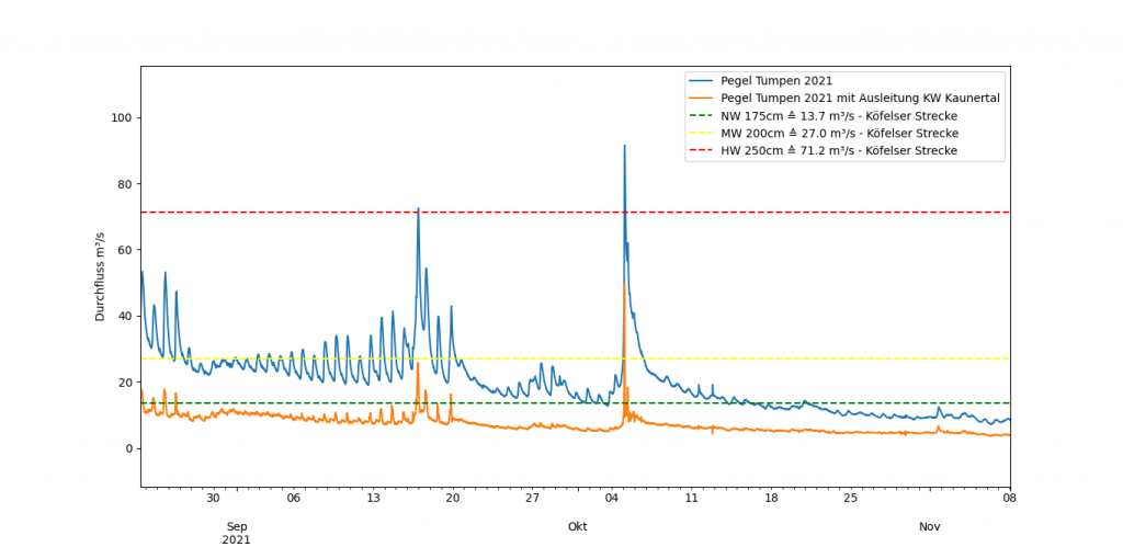
Tumpen gauge with / without diversions (autumn)
Orange curve: Tumpen gauge 2021 minus 80% of the flow Q at the Huben gauge (corrected for flow time) up to a Q of 100m³/s (80m³/s discharge plus 20% residual water) – At higher levels, the overflow remains in the river. The water intake for the Sellrain-Silz hydroelectric power station is not included here, as we do not know how much is diverted in autumn.
In Ötztal you can learn to paddle – and become a pro. It’s not by chance that the world-famous Wellerbrücke section is home to the Extreme Kayaking World Championships, it’s not by chance that a considerable amount of world class pro kayakers have made the region their chosen home. Even if a few sections of the Ötztaler Ache were to be preserved at certain times of the year or for any given days – for kayakers the attractiveness of the Ötztal lies in the choice and variety of sections as well as the water safety in autumn. With the diversions none of this would be given anymore and the valley would thus lose its attractiveness for kayak tourism. Help us to preserve this cultural heritage for kayakers!
Sources and links
(1) TIWAG- Tiroler Wasserkraft AG, Innsbruck; Ausbau Kraftwerk Kaunertal – Stellungnahme der Landesumweltanwaltschaft gemäß § 5 Abs 4 UVP-G 2000, 2012
(3) TIWAG Website: Ausbau KW Kaunertal
(4) water level data: Hydrographischer Dienst Tirol
Naturally, most of these are in German, we have put them here anyway for accountability. However, the Hydropower Sustainability Assessment Protocol (HSAP) for the project is available in English and offers a wealth of information. Also the TIWAG offers some information on the project in english on their website.